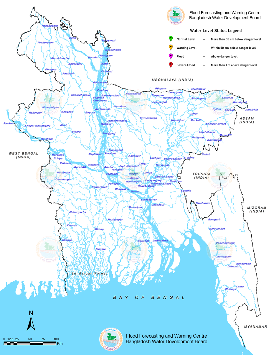
Severe
  Danger
  Warning
  Normal
  South Eastern Hill
  Ganges
  Meghna
  Brahmaputra
Station Name: Chiringa
Station ID: SW204
River Name: Matamuhuri
Division: Chittagong
District: Cox's Bazar
Upazilla: Chakaria
Union: Baraitali
Water Level: 1.42 mMSL
(Recorded At: 19-May-2026 15:00)
Highest Water Level: 7.28 mMSL
Danger Level: 5.80 mMSL
Status: 438cm Below Danger Level
Trend (Last 3-hour): Rising 🡅 (+79cm)
Last 24h Rise/Fall: -15cm
Station Name: Lama
Station ID: SW203
River Name: Matamuhuri
Division: Chittagong
District: Bandarban
Upazilla: Lama
Union:
Water Level: 5.35 mMSL
(Recorded At: 19-May-2026 15:00)
Highest Water Level: 14.92 mMSL
Danger Level: 11.80 mMSL
Status: 645cm Below Danger Level
Trend (Last 3-hour): Falling 🡇 (-1cm)
Last 24h Rise/Fall: -3cm
Station Name: Dohazari
Station ID: SW248
River Name: Sangu
Division: Chittagong
District: Chittagong
Upazilla: Chandanaish
Union: Hashimpur
Water Level: 2.24 mMSL
(Recorded At: 19-May-2026 15:00)
Highest Water Level: 7.63 mMSL
Danger Level: 6.55 mMSL
Status: 431cm Below Danger Level
Trend (Last 3-hour): Rising 🡅 (+185cm)
Last 24h Rise/Fall: -28cm
Station Name: Bandarban
Station ID: SW247
River Name: Sangu
Division: Chittagong
District: Bandarban
Upazilla: Bandarban Sadar
Union: Kuhalong
Water Level: 3.46 mMSL
(Recorded At: 19-May-2026 15:00)
Highest Water Level: 20.34 mMSL
Danger Level: 14.80 mMSL
Status: 1134cm Below Danger Level
Trend (Last 3-hour): Falling 🡇 (-2cm)
Last 24h Rise/Fall: +4cm
Station Name: Mongla
Station ID: SW244
River Name: Passur
Division: Khulna
District: Bagerhat
Upazilla: Mongla
Union: Paurashava
Water Level: 2.00 mMSL
(Recorded At: 19-May-2026 15:00)
Highest Water Level: 3.33 mMSL
Danger Level: 1.80 mMSL
Status: 20cm Above Danger Level
Trend (Last 3-hour): Rising 🡅 (+26cm)
Last 24h Rise/Fall: +15cm
Station Name: Panchpukuria
Station ID: SW119.1
River Name: Halda
Division: Chittagong
District: Chittagong
Upazilla: Fatikchhari
Union: Samitirhat
Water Level: 0.57 mMSL
(Recorded At: 19-May-2026 15:00)
Highest Water Level: 11.46 mMSL
Danger Level: 9.05 mMSL
Status: 848cm Below Danger Level
Trend (Last 3-hour): Falling 🡇 (-12cm)
Last 24h Rise/Fall: -30cm
Station Name: Daulatkhan
Station ID: SW278
River Name: Lower Meghna
Division: Barisal
District: Bhola
Upazilla: Daulatkhan
Union: Char Pata
Water Level: 2.40 mMSL
(Recorded At: 19-May-2026 15:00)
Highest Water Level: 4.03 mMSL
Danger Level: 2.95 mMSL
Status: 55cm Below Danger Level
Trend (Last 3-hour): Rising 🡅 (+182cm)
Last 24h Rise/Fall: -30cm
Station Name: Shakra
Station ID: SW128
River Name: Ichamati
Division: Khulna
District: Satkhira
Upazilla: Debhata
Union: Parulia
Water Level: 2.64 mMSL
(Recorded At: 19-May-2026 15:00)
Highest Water Level: 3.98 mMSL
Danger Level: 3.50 mMSL
Status: 86cm Below Danger Level
Trend (Last 3-hour): Rising 🡅 (+110cm)
Last 24h Rise/Fall: +16cm
Station Name: Narayanhat
Station ID: SW117
River Name: Halda
Division: Chittagong
District: Chittagong
Upazilla: Fatikchhari
Union: Narayanhat
Water Level: 8.96 mMSL
(Recorded At: 19-May-2026 15:00)
Highest Water Level: 16.92 mMSL
Danger Level: 14.80 mMSL
Status: 584cm Below Danger Level
Trend (Last 3-hour): Steady 🠶 (0cm)
Last 24h Rise/Fall: -4cm
Station Name: Khulna
Station ID: SW241
River Name: Rupsa
Division: Khulna
District: Khulna
Upazilla: Khalishpur Thana
Union: Paurashava
Water Level: 2.23 mMSL
(Recorded At: 19-May-2026 15:00)
Highest Water Level: 3.49 mMSL
Danger Level: 2.60 mMSL
Status: 37cm Below Danger Level
Trend (Last 3-hour): Rising 🡅 (+105cm)
Last 24h Rise/Fall: +5cm
Station Name: Kalaroa
Station ID: SW23
River Name: Betna
Division: Khulna
District: Satkhira
Upazilla: Kalaroa
Union: Helatala
Water Level: 1.32 mMSL
(Recorded At: 19-May-2026 15:00)
Highest Water Level: 4.74 mMSL
Danger Level: 3.35 mMSL
Status: 203cm Below Danger Level
Trend (Last 3-hour): Falling 🡇 (-5cm)
Last 24h Rise/Fall: -9cm
Station Name: Ramgarh
Station ID: SW84
River Name: Feni
Division: Chittagong
District: Chittagong
Upazilla: Fatikchhari
Union: Bagan Bazar
Water Level: 10.38 mMSL
(Recorded At: 19-May-2026 15:00)
Highest Water Level: 19.85 mMSL
Danger Level: 16.90 mMSL
Status: 652cm Below Danger Level
Trend (Last 3-hour): Steady 🠶 (0cm)
Last 24h Rise/Fall: -1cm
Station Name: Jhikargacha
Station ID: SW162
River Name: Kobadak
Division: Khulna
District: Jessore
Upazilla: Jhikargachha
Union: Gadkhali
Water Level: 1.01 mMSL
(Recorded At: 19-May-2026 15:00)
Highest Water Level: 4.94 mMSL
Danger Level: 4.65 mMSL
Status: 364cm Below Danger Level
Trend (Last 3-hour): Steady 🠶 (0cm)
Last 24h Rise/Fall: +2cm
Station Name: Madaripur
Station ID: SW5
River Name: Arialkhan
Division: Dhaka
District: Madaripur
Upazilla: Madaripur Sadar
Union: Paurashava
Water Level: 1.34 mMSL
(Recorded At: 19-May-2026 15:00)
Highest Water Level: 5.37 mMSL
Danger Level: 3.75 mMSL
Status: 241cm Below Danger Level
Trend (Last 3-hour): Falling 🡇 (-18cm)
Last 24h Rise/Fall: +9cm
Station Name: Chandpur
Station ID: SW277
River Name: Lower Meghna
Division: Chittagong
District: Chandpur
Upazilla: Chandpur Sadar
Union: Paurashava
Water Level: 0.81 mMSL
(Recorded At: 19-May-2026 15:00)
Highest Water Level: 5.11 mMSL
Danger Level: 3.55 mMSL
Status: 274cm Below Danger Level
Trend (Last 3-hour): Falling 🡇 (-40cm)
Last 24h Rise/Fall: -18cm
Station Name: Parshuram
Station ID: SW212
River Name: Muhuri
Division: Chittagong
District: Feni
Upazilla: Parshuram
Union: Mirzanagar
Water Level: 7.41 mMSL
(Recorded At: 19-May-2026 15:00)
Highest Water Level: 14.79 mMSL
Danger Level: 12.55 mMSL
Status: 514cm Below Danger Level
Trend (Last 3-hour): Falling 🡇 (-17cm)
Last 24h Rise/Fall: -10cm
Station Name: Sureshswar
Station ID: SW95
River Name: Padma
Division: Dhaka
District: Shariatpur
Upazilla: Naria
Union: Kedarpur
Water Level: 1.46 mMSL
(Recorded At: 19-May-2026 15:00)
Highest Water Level: 4.92 mMSL
Danger Level: 4.00 mMSL
Status: 254cm Below Danger Level
Trend (Last 3-hour): Falling 🡇 (-30cm)
Last 24h Rise/Fall: +11cm
Station Name: Comilla
Station ID: SW110
River Name: Gumti
Division: Chittagong
District: Comilla
Upazilla: Comilla Sadar
Union: Panchthubi
Water Level: 5.80 mMSL
(Recorded At: 19-May-2026 15:00)
Highest Water Level: 12.54 mMSL
Danger Level: 11.30 mMSL
Status: 550cm Below Danger Level
Trend (Last 3-hour): Falling 🡇 (-5cm)
Last 24h Rise/Fall: +78cm
Station Name: Kamarkhali
Station ID: SW101B
River Name: Gorai
Division: Khulna
District: Magura
Upazilla: Magura Sadar
Union: Kasundi
Water Level: 1.54 mMSL
(Recorded At: 19-May-2026 15:00)
Highest Water Level: 8.61 mMSL
Danger Level: 7.75 mMSL
Status: 621cm Below Danger Level
Trend (Last 3-hour): Falling 🡇 (-4cm)
Last 24h Rise/Fall: +6cm
Station Name: Bhagyakul
Station ID: SW93.4
River Name: Padma
Division: Dhaka
District: Munshiganj
Upazilla: Sreenagar
Union: Baghra
Water Level: 2.23 mMSL
(Recorded At: 19-May-2026 15:00)
Highest Water Level: 6.76 mMSL
Danger Level: 5.85 mMSL
Status: 362cm Below Danger Level
Trend (Last 3-hour): Falling 🡇 (-23cm)
Last 24h Rise/Fall: +8cm
Station Name: Faridpur
Station ID: SW168
River Name: Kumar
Division: Dhaka
District: Faridpur
Upazilla: Faridpur Sadar
Union: Aliabad
Water Level: 1.23 mMSL
(Recorded At: 19-May-2026 15:00)
Highest Water Level: 8.70 mMSL
Danger Level: 7.05 mMSL
Status: 582cm Below Danger Level
Trend (Last 3-hour): Steady 🠶 (0cm)
Last 24h Rise/Fall: +6cm
Station Name: Hariharpara
Station ID: SW43
River Name: Buriganga
Division: Dhaka
District: Dhaka
Upazilla: Keraniganj
Union: Konda
Water Level: 1.69 mMSL
(Recorded At: 19-May-2026 15:00)
Highest Water Level: 8.16 mMSL
Danger Level: 5.35 mMSL
Status: 366cm Below Danger Level
Trend (Last 3-hour): Falling 🡇 (-23cm)
Last 24h Rise/Fall: -4cm
Station Name: Debidwar
Station ID: SW114
River Name: Gumti
Division: Chittagong
District: Comilla
Upazilla: Debidwar
Union: Debidwar
Water Level: 2.98 mMSL
(Recorded At: 19-May-2026 15:00)
Highest Water Level: 9.36 mMSL
Danger Level: 8.05 mMSL
Status: 507cm Below Danger Level
Trend (Last 3-hour): Rising 🡅 (+10cm)
Last 24h Rise/Fall: +31cm
Station Name: Chuadanga
Station ID: SW207
River Name: Mathabhanga
Division: Khulna
District: Chuadanga
Upazilla: Chuadanga Sadar
Union: Alokdia
Water Level: 4.52 mMSL
(Recorded At: 19-May-2026 15:00)
Highest Water Level: 11.84 mMSL
Danger Level: 11.60 mMSL
Status: 708cm Below Danger Level
Trend (Last 3-hour): Falling 🡇 (-1cm)
Last 24h Rise/Fall: +6cm
Station Name: Narayanganj
Station ID: SW180
River Name: Lakhya
Division: Dhaka
District: Narayanganj
Upazilla: Narayanganj Sadar
Union: Sumil Para
Water Level: 1.68 mMSL
(Recorded At: 19-May-2026 15:00)
Highest Water Level: 5.62 mMSL
Danger Level: 5.05 mMSL
Status: 337cm Below Danger Level
Trend (Last 3-hour): Falling 🡇 (-34cm)
Last 24h Rise/Fall: +11cm
Station Name: Dhaka
Station ID: SW42
River Name: Buriganga
Division: Dhaka
District: Dhaka
Upazilla: Keraniganj
Union: Subhadya
Water Level: 1.64 mMSL
(Recorded At: 19-May-2026 15:00)
Highest Water Level: 6.69 mMSL
Danger Level: 5.55 mMSL
Status: 391cm Below Danger Level
Trend (Last 3-hour): Falling 🡇 (-36cm)
Last 24h Rise/Fall: +4cm
Station Name: Demra
Station ID: SW7.5
River Name: Balu
Division: Dhaka
District: Dhaka
Upazilla: Demra Thana
Union: Demra Psa
Water Level: 1.90 mMSL
(Recorded At: 19-May-2026 15:00)
Highest Water Level: 5.90 mMSL
Danger Level: 5.30 mMSL
Status: 340cm Below Danger Level
Trend (Last 3-hour): Falling 🡇 (-27cm)
Last 24h Rise/Fall: +9cm
Station Name: Goalondo
Station ID: SW91.9R
River Name: Ganges
Division: Dhaka
District: Rajbari
Upazilla: Goalanda
Union: Debagram
Water Level: 3.83 mMSL
(Recorded At: 19-May-2026 15:00)
Highest Water Level: 9.45 mMSL
Danger Level: 8.20 mMSL
Status: 437cm Below Danger Level
Trend (Last 3-hour): Rising 🡅 (+2cm)
Last 24h Rise/Fall: +6cm
Station Name: Mirpur
Station ID: SW302
River Name: Turag
Division: Dhaka
District: Dhaka
Upazilla: Mirpur Thana
Union: Mirpur
Water Level: 2.00 mMSL
(Recorded At: 19-May-2026 15:00)
Highest Water Level: 7.22 mMSL
Danger Level: 5.50 mMSL
Status: 350cm Below Danger Level
Trend (Last 3-hour): Falling 🡇 (-18cm)
Last 24h Rise/Fall: +2cm
Station Name: Hatboalia
Station ID: SW206
River Name: Mathabhanga
Division: Khulna
District: Chuadanga
Upazilla: Alamdanga
Union: Bhangabaria
Water Level: 6.11 mMSL
(Recorded At: 19-May-2026 15:00)
Highest Water Level: 14.67 mMSL
Danger Level: 14.05 mMSL
Status: 794cm Below Danger Level
Trend (Last 3-hour): Steady 🠶 (0cm)
Last 24h Rise/Fall: +4cm
Station Name: Taraghat
Station ID: SW137A
River Name: Kaliganga
Division: Dhaka
District: Manikganj
Upazilla: Manikganj Sadar
Union: Dighi
Water Level: 2.30 mMSL
(Recorded At: 19-May-2026 15:00)
Highest Water Level: 9.62 mMSL
Danger Level: 7.95 mMSL
Status: 565cm Below Danger Level
Trend (Last 3-hour): Falling 🡇 (-2cm)
Last 24h Rise/Fall: +6cm
Station Name: Aricha
Station ID: SW50.6
River Name: Jamuna
Division: Dhaka
District: Manikganj
Upazilla: Shibalaya
Union: Teota
Water Level: 3.78 mMSL
(Recorded At: 19-May-2026 15:00)
Highest Water Level: 9.90 mMSL
Danger Level: 8.95 mMSL
Status: 517cm Below Danger Level
Trend (Last 3-hour): Falling 🡇 (-1cm)
Last 24h Rise/Fall: -3cm
Station Name: Jagir
Station ID: SW68.5
River Name: Old Dhaleswari
Division: Dhaka
District: Manikganj
Upazilla: Manikganj Sadar
Union: Jaigir
Water Level: 2.11 mMSL
(Recorded At: 19-May-2026 15:00)
Highest Water Level: 9.15 mMSL
Danger Level: 7.80 mMSL
Status: 569cm Below Danger Level
Trend (Last 3-hour): Rising 🡅 (+1cm)
Last 24h Rise/Fall: +4cm
Station Name: Gorai-RB
Station ID: SW99
River Name: Gorai
Division: Khulna
District: Kushtia
Upazilla: Kumarkhali
Union: Chapra
Water Level: 3.59 mMSL
(Recorded At: 19-May-2026 15:00)
Highest Water Level: 12.91 mMSL
Danger Level: 12.30 mMSL
Status: 871cm Below Danger Level
Trend (Last 3-hour): Rising 🡅 (+1cm)
Last 24h Rise/Fall: +2cm
Station Name: Tongi
Station ID: SW299
River Name: Tongi Khal
Division: Dhaka
District: Gazipur
Upazilla: Gazipur Sadar
Union: Paurashava
Water Level: 2.46 mMSL
(Recorded At: 19-May-2026 15:00)
Highest Water Level: 6.68 mMSL
Danger Level: 5.65 mMSL
Status: 319cm Below Danger Level
Trend (Last 3-hour): Rising 🡅 (+3cm)
Last 24h Rise/Fall: +13cm
Station Name: Bhairabbazar
Station ID: SW273
River Name: Upper Meghna
Division: Dhaka
District: Kishorganj
Upazilla: Bhairab
Union: Paurashava
Water Level: 2.07 mMSL
(Recorded At: 19-May-2026 15:00)
Highest Water Level: 6.69 mMSL
Danger Level: 5.80 mMSL
Status: 373cm Below Danger Level
Trend (Last 3-hour): Falling 🡇 (-16cm)
Last 24h Rise/Fall: -12cm
Station Name: Hardinge-RB
Station ID: SW90
River Name: Ganges
Division: Rajshahi
District: Pabna
Upazilla: Ishwardi
Union: Pakshi
Water Level: 5.04 mMSL
(Recorded At: 19-May-2026 15:00)
Highest Water Level: 14.33 mMSL
Danger Level: 13.80 mMSL
Status: 876cm Below Danger Level
Trend (Last 3-hour): Falling 🡇 (-1cm)
Last 24h Rise/Fall: -3cm
Station Name: Nayarhat
Station ID: SW14.5
River Name: Bangshi
Division: Dhaka
District: Tangail
Upazilla: Mirzapur
Union: Ajgana
Water Level: 1.54 mMSL
(Recorded At: 19-May-2026 15:00)
Highest Water Level: 9.18 mMSL
Danger Level: 6.85 mMSL
Status: 531cm Below Danger Level
Trend (Last 3-hour): Falling 🡇 (-11cm)
Last 24h Rise/Fall: -1cm
Station Name: Rajshahi
Station ID: SW88
River Name: Ganges
Division: Rajshahi
District: Rajshahi
Upazilla: Paba
Union: Haripur
Water Level: 7.89 mMSL
(Recorded At: 19-May-2026 15:00)
Highest Water Level: 19.47 mMSL
Danger Level: 18.05 mMSL
Status: 1016cm Below Danger Level
Trend (Last 3-hour): Falling 🡇 (-1cm)
Last 24h Rise/Fall: -14cm
Station Name: Habiganj
Station ID: SW159
River Name: Khowai
Division: Sylhet
District: Habiganj
Upazilla: Baniachong
Union: Umednagar
Water Level: 6.85 mMSL
(Recorded At: 19-May-2026 15:00)
Highest Water Level: 10.93 mMSL
Danger Level: 9.05 mMSL
Status: 220cm Below Danger Level
Trend (Last 3-hour): Rising 🡅 (+5cm)
Last 24h Rise/Fall: +175cm
Station Name: Manu-RB
Station ID: SW201
River Name: Manu
Division: Sylhet
District: Maulvibazar
Upazilla: Kulaura
Union: Tilagaon
Water Level: 13.53 mMSL
(Recorded At: 19-May-2026 15:00)
Highest Water Level: 19.17 mMSL
Danger Level: 17.55 mMSL
Status: 402cm Below Danger Level
Trend (Last 3-hour): Falling 🡇 (-2cm)
Last 24h Rise/Fall: +68cm
Station Name: Serajganj
Station ID: SW49
River Name: Jamuna
Division: Rajshahi
District: Sirajganj
Upazilla: Sirajganj Sadar
Union: Paurashava
Water Level: 8.48 mMSL
(Recorded At: 19-May-2026 15:00)
Highest Water Level: 14.70 mMSL
Danger Level: 12.90 mMSL
Status: 442cm Below Danger Level
Trend (Last 3-hour): Rising 🡅 (+1cm)
Last 24h Rise/Fall: +23cm
Station Name: Moulvibazar
Station ID: SW202
River Name: Manu
Division: Sylhet
District: Maulvibazar
Upazilla: Rajnagar
Union: Kamar Chak
Water Level: 8.34 mMSL
(Recorded At: 19-May-2026 15:00)
Highest Water Level: 12.14 mMSL
Danger Level: 11.30 mMSL
Status: 296cm Below Danger Level
Trend (Last 3-hour): Rising 🡅 (+3cm)
Last 24h Rise/Fall: +46cm
Station Name: Atrai
Station ID: SW147
River Name: Atrai
Division: Rajshahi
District: Naogaon
Upazilla: Atrai
Union: Bhopara
Water Level: 10.19 mMSL
(Recorded At: 19-May-2026 15:00)
Highest Water Level: 13.94 mMSL
Danger Level: 13.25 mMSL
Status: 306cm Below Danger Level
Trend (Last 3-hour): Falling 🡇 (-1cm)
Last 24h Rise/Fall: +3cm
Station Name: C-Nawabganj
Station ID: SW211.5
River Name: Mohananda
Division: Rajshahi
District: Chapai Nawabganj
Upazilla: Nawabganj Sadar
Union: Balidanga
Water Level: 13.24 mMSL
(Recorded At: 19-May-2026 15:00)
Highest Water Level: 22.39 mMSL
Danger Level: 20.55 mMSL
Status: 731cm Below Danger Level
Trend (Last 3-hour): Steady 🠶 (0cm)
Last 24h Rise/Fall: 0cm
Station Name: Sherpur-Sylhet
Station ID: SW175.5
River Name: Kushiyara
Division: Sylhet
District: Maulvibazar
Upazilla: Maulvi Bazar Sadar
Union: Khalilpur
Water Level: 6.57 mMSL
(Recorded At: 19-May-2026 15:00)
Highest Water Level: 8.79 mMSL
Danger Level: 8.55 mMSL
Status: 198cm Below Danger Level
Trend (Last 3-hour): Rising 🡅 (+1cm)
Last 24h Rise/Fall: +3cm
Station Name: Mymensingh
Station ID: SW228.5
River Name: Old Brahmaputra
Division: Dhaka
District: Mymensingh
Upazilla: Gauripur
Union: Bhangnamari
Water Level: 3.15 mMSL
(Recorded At: 19-May-2026 15:00)
Highest Water Level: 12.73 mMSL
Danger Level: 12.05 mMSL
Status: 890cm Below Danger Level
Trend (Last 3-hour): Falling 🡇 (-1cm)
Last 24h Rise/Fall: +8cm
Station Name: Mohadevpur
Station ID: SW145
River Name: Atrai
Division: Rajshahi
District: Naogaon
Upazilla: Manda
Union: Bhalain
Water Level: 13.46 mMSL
(Recorded At: 19-May-2026 15:00)
Highest Water Level: 19.40 mMSL
Danger Level: 18.15 mMSL
Status: 469cm Below Danger Level
Trend (Last 3-hour): Falling 🡇 (-3cm)
Last 24h Rise/Fall: -19cm
Station Name: Bogra
Station ID: SW65
River Name: Karatoa
Division: Rajshahi
District: Bogra
Upazilla: Shajahanpur
Union: Sultanganj
Water Level: 10.60 mMSL
(Recorded At: 19-May-2026 15:00)
Highest Water Level: 16.61 mMSL
Danger Level: 15.85 mMSL
Status: 525cm Below Danger Level
Trend (Last 3-hour): Falling 🡇 (-1cm)
Last 24h Rise/Fall: -7cm
Station Name: Chakrahimpur
Station ID: SW63
River Name: Karatoa
Division: Rajshahi
District: Gaibandha
Upazilla: Gobindaganj
Union: Gobindaganj Psa
Water Level: 15.91 mMSL
(Recorded At: 19-May-2026 15:00)
Highest Water Level: 20.95 mMSL
Danger Level: 19.70 mMSL
Status: 379cm Below Danger Level
Trend (Last 3-hour): Rising 🡅 (+4cm)
Last 24h Rise/Fall: +39cm
Station Name: Naogaon
Station ID: SW133
River Name: Little Jamuna
Division: Rajshahi
District: Naogaon
Upazilla: Naogaon Sadar
Union: Tilakpur
Water Level: 10.91 mMSL
(Recorded At: 19-May-2026 15:00)
Highest Water Level: 15.73 mMSL
Danger Level: 14.80 mMSL
Status: 389cm Below Danger Level
Trend (Last 3-hour): Falling 🡇 (-2cm)
Last 24h Rise/Fall: -8cm
Station Name: Rohanpur
Station ID: SW238
River Name: Punarvaba
Division: Rajshahi
District: Chapai Nawabganj
Upazilla: Gomastapur
Union: Bhangabaria
Water Level: 13.73 mMSL
(Recorded At: 19-May-2026 15:00)
Highest Water Level: 23.65 mMSL
Danger Level: 21.55 mMSL
Status: 782cm Below Danger Level
Trend (Last 3-hour): Steady 🠶 (0cm)
Last 24h Rise/Fall: -1cm
Station Name: Sylhet
Station ID: SW267
River Name: Surma
Division: Sylhet
District: Sylhet
Upazilla: Sylhet Sadar
Union: Baraikandi
Water Level: 7.56 mMSL
(Recorded At: 19-May-2026 15:00)
Highest Water Level: 11.69 mMSL
Danger Level: 10.80 mMSL
Status: 324cm Below Danger Level
Trend (Last 3-hour): Falling 🡇 (-4cm)
Last 24h Rise/Fall: -29cm
Station Name: Amalshid
Station ID: SW172
River Name: Kushiyara
Division: Sylhet
District: Sylhet
Upazilla: Zakiganj
Union: Bara Thakuri
Water Level: 11.39 mMSL
(Recorded At: 19-May-2026 15:00)
Highest Water Level: 17.57 mMSL
Danger Level: 15.40 mMSL
Status: 401cm Below Danger Level
Trend (Last 3-hour): Falling 🡇 (-8cm)
Last 24h Rise/Fall: -67cm
Station Name: Sheola
Station ID: SW173
River Name: Kushiyara
Division: Sylhet
District: Sylhet
Upazilla: Beani Bazar
Union: Sheola
Water Level: 9.30 mMSL
(Recorded At: 19-May-2026 15:00)
Highest Water Level: 13.72 mMSL
Danger Level: 13.05 mMSL
Status: 375cm Below Danger Level
Trend (Last 3-hour): Falling 🡇 (-5cm)
Last 24h Rise/Fall: -46cm
Station Name: Jamalpur
Station ID: SW225
River Name: Old Brahmaputra
Division: Dhaka
District: Jamalpur
Upazilla: Jamalpur Sadar
Union: Char Pakshimari
Water Level: 8.80 mMSL
(Recorded At: 19-May-2026 15:00)
Highest Water Level: 17.20 mMSL
Danger Level: 16.55 mMSL
Status: 775cm Below Danger Level
Trend (Last 3-hour): Rising 🡅 (+1cm)
Last 24h Rise/Fall: +7cm
Station Name: Jariajanjail
Station ID: SW36
River Name: Kangsha
Division: Dhaka
District: Netrokona
Upazilla: Durgapur
Union: Kakairgara
Water Level: 8.00 mMSL
(Recorded At: 19-May-2026 15:00)
Highest Water Level: 11.08 mMSL
Danger Level: 10.55 mMSL
Status: 255cm Below Danger Level
Trend (Last 3-hour): Falling 🡇 (-1cm)
Last 24h Rise/Fall: -17cm
Station Name: Kanaighat
Station ID: SW266
River Name: Surma
Division: Sylhet
District: Sylhet
Upazilla: Kanaighat
Union: Paschim Dighirpar
Water Level: 9.75 mMSL
(Recorded At: 19-May-2026 15:00)
Highest Water Level: 14.63 mMSL
Danger Level: 12.75 mMSL
Status: 300cm Below Danger Level
Trend (Last 3-hour): Falling 🡇 (-5cm)
Last 24h Rise/Fall: -61cm
Station Name: Sunamganj
Station ID: SW269
River Name: Surma
Division: Sylhet
District: Sunamganj
Upazilla: Sunamganj Sadar
Union: Paurashava
Water Level: 5.40 mMSL
(Recorded At: 19-May-2026 15:00)
Highest Water Level: 9.00 mMSL
Danger Level: 6.05 mMSL
Status: 65cm Below Danger Level
Trend (Last 3-hour): Falling 🡇 (-1cm)
Last 24h Rise/Fall: -5cm
Station Name: Bahadurabad
Station ID: SW46.9L
River Name: Jamuna
Division: Dhaka
District: Jamalpur
Upazilla: Islampur
Union: Belgachha
Water Level: 15.21 mMSL
(Recorded At: 19-May-2026 15:00)
Highest Water Level: 20.63 mMSL
Danger Level: 19.05 mMSL
Status: 384cm Below Danger Level
Trend (Last 3-hour): Rising 🡅 (+1cm)
Last 24h Rise/Fall: +5cm
Station Name: Durgapur
Station ID: SW263
River Name: Someswari
Division: Dhaka
District: Netrokona
Upazilla: Durgapur
Union: Kullagora
Water Level: 8.28 mMSL
(Recorded At: 19-May-2026 15:00)
Highest Water Level: 14.98 mMSL
Danger Level: 12.55 mMSL
Status: 427cm Below Danger Level
Trend (Last 3-hour): Falling 🡇 (-1cm)
Last 24h Rise/Fall: -29cm
Station Name: Sarighat
Station ID: SW251
River Name: Sarigowain
Division: Sylhet
District: Sylhet
Upazilla: Gowainghat
Union: Purba Jaflong
Water Level: 7.16 mMSL
(Recorded At: 19-May-2026 15:00)
Highest Water Level: 13.53 mMSL
Danger Level: 12.35 mMSL
Status: 519cm Below Danger Level
Trend (Last 3-hour): Falling 🡇 (-8cm)
Last 24h Rise/Fall: -39cm
Station Name: Nakuagaon
Station ID: SW34
River Name: Bhugai
Division: Dhaka
District: Sherpur
Upazilla: Nalitabari
Union: Ramchandrakura Mandalia
Water Level: 17.67 mMSL
(Recorded At: 19-May-2026 15:00)
Highest Water Level: 25.00 mMSL
Danger Level: 21.95 mMSL
Status: 428cm Below Danger Level
Trend (Last 3-hour): Falling 🡇 (-5cm)
Last 24h Rise/Fall: -65cm
Station Name: Lourergorh
Station ID: SW131.5
River Name: Jadukata
Division: Sylhet
District: Sunamganj
Upazilla: Tahirpur
Union: Uttar Badal
Water Level: 5.23 mMSL
(Recorded At: 19-May-2026 15:00)
Highest Water Level: 11.99 mMSL
Danger Level: 8.05 mMSL
Status: 282cm Below Danger Level
Trend (Last 3-hour): Falling 🡇 (-1cm)
Last 24h Rise/Fall: -2cm
Station Name: Gaibandha
Station ID: SW97
River Name: Ghagot
Division: Rangpur
District: Gaibandha
Upazilla: Gaibandha Sadar
Union: Kholahati
Water Level: 17.66 mMSL
(Recorded At: 19-May-2026 15:00)
Highest Water Level: 22.06 mMSL
Danger Level: 21.25 mMSL
Status: 359cm Below Danger Level
Trend (Last 3-hour): Steady 🠶 (0cm)
Last 24h Rise/Fall: +20cm
Station Name: Chilmari
Station ID: SW45.5
River Name: Brahmaputra
Division: Rangpur
District: Kurigram
Upazilla: Chilmari
Union: Chilmari
Water Level: 19.83 mMSL
(Recorded At: 19-May-2026 15:00)
Highest Water Level: 24.37 mMSL
Danger Level: 23.25 mMSL
Status: 342cm Below Danger Level
Trend (Last 3-hour): Steady 🠶 (0cm)
Last 24h Rise/Fall: +2cm
Station Name: Bhusirbandar
Station ID: SW142.5
River Name: Upper Atrai
Division: Rangpur
District: Dinajpur
Upazilla: Chirirbdndar
Union: Bhiail
Water Level: 35.33 mMSL
(Recorded At: 19-May-2026 15:00)
Highest Water Level: 39.43 mMSL
Danger Level: 39.15 mMSL
Status: 382cm Below Danger Level
Trend (Last 3-hour): Rising 🡅 (+1cm)
Last 24h Rise/Fall: +28cm
Station Name: Dinajpur
Station ID: SW236
River Name: Punarbhaba
Division: Rangpur
District: Dinajpur
Upazilla: Dinajpur Sadar
Union: Chehelgazi
Water Level: 26.55 mMSL
(Recorded At: 19-May-2026 15:00)
Highest Water Level: 34.36 mMSL
Danger Level: 33.05 mMSL
Status: 650cm Below Danger Level
Trend (Last 3-hour): Rising 🡅 (+1cm)
Last 24h Rise/Fall: -3cm
Station Name: Kaunia
Station ID: SW294
River Name: Teesta
Division: Rangpur
District: Rangpur
Upazilla: Kaunia
Union: Balapara
Water Level: 28.38 mMSL
(Recorded At: 19-May-2026 15:00)
Highest Water Level: 30.42 mMSL
Danger Level: 29.31 mMSL
Status: 93cm Below Danger Level
Trend (Last 3-hour): Falling 🡇 (-4cm)
Last 24h Rise/Fall: -26cm
Station Name: Badarganj
Station ID: SW62
River Name: Jamuneswari
Division: Rangpur
District: Rangpur
Upazilla: Taraganj
Union: Kursha
Water Level: 28.60 mMSL
(Recorded At: 19-May-2026 15:00)
Highest Water Level: 33.10 mMSL
Danger Level: 31.70 mMSL
Status: 310cm Below Danger Level
Trend (Last 3-hour): Falling 🡇 (-1cm)
Last 24h Rise/Fall: +9cm
Station Name: Kurigram
Station ID: SW77
River Name: Dharla
Division: Rangpur
District: Kurigram
Upazilla: Kurigram Sadar
Union: Paurashava
Water Level: 22.75 mMSL
(Recorded At: 19-May-2026 15:00)
Highest Water Level: 27.18 mMSL
Danger Level: 26.05 mMSL
Status: 330cm Below Danger Level
Trend (Last 3-hour): Falling 🡇 (-2cm)
Last 24h Rise/Fall: +8cm
Station Name: Noonkhawa
Station ID: SW45
River Name: Brahmaputra
Division: Rangpur
District: Kurigram
Upazilla: Nageshwari
Union: Kaliganj
Water Level: 22.18 mMSL
(Recorded At: 19-May-2026 15:00)
Highest Water Level: 27.63 mMSL
Danger Level: 26.05 mMSL
Status: 387cm Below Danger Level
Trend (Last 3-hour): Falling 🡇 (-1cm)
Last 24h Rise/Fall: -2cm
Station Name: Phulbari
Station ID: SW132.2
River Name: Ichamati-Jamuna
Division: Rangpur
District: Dinajpur
Upazilla: Birganj
Union: Mohanpur
Water Level: 26.19 mMSL
(Recorded At: 19-May-2026 15:00)
Highest Water Level: 30.01 mMSL
Danger Level: 29.50 mMSL
Status: 331cm Below Danger Level
Trend (Last 3-hour): Falling 🡇 (-1cm)
Last 24h Rise/Fall: -12cm
Station Name: Dalia
Station ID: SW291.5R
River Name: Teesta
Division: Rangpur
District: Nilphamari
Upazilla: Dimla
Union: Khalisa Chapani
Water Level: 51.48 mMSL
(Recorded At: 19-May-2026 15:00)
Highest Water Level: 52.90 mMSL
Danger Level: 52.15 mMSL
Status: 67cm Below Danger Level
Trend (Last 3-hour): Rising 🡅 (+3cm)
Last 24h Rise/Fall: +10cm
Station Name: Panchagarh
Station ID: SW140
River Name: Upper Karatoa
Division: Rangpur
District: Panchagarh
Upazilla: Panchagar Sadar
Union: Panchagarh
Water Level: 64.47 mMSL
(Recorded At: 19-May-2026 15:00)
Highest Water Level: 72.03 mMSL
Danger Level: 70.30 mMSL
Status: 583cm Below Danger Level
Trend (Last 3-hour): Steady 🠶 (0cm)
Last 24h Rise/Fall: -6cm
Station Name: Pankha
Station ID: SW88A
River Name: Ganges
Division: Rajshahi
District: Nawabganj
Upazilla: Shibganj
Union: Panka
Water Level: 12.17 mMSL
(Recorded At: 19-May-2026 15:00)
Highest Water Level: 23.67 mMSL
Danger Level: 22.05 mMSL
Status: 988cm Below Danger Level
Trend (Last 3-hour): Falling 🡇 (-1cm)
Last 24h Rise/Fall: -23cm
Station Name: Bayderbazar
Station ID: SW275
River Name: Meghna
Division: Dhaka
District: Narayanganj
Upazilla: Araihazar
Union: Bishnandi
Water Level: 1.72 mMSL
(Recorded At: 19-May-2026 15:00)
Highest Water Level: 7.39 mMSL
Danger Level: 4.70 mMSL
Status: 298cm Below Danger Level
Trend (Last 3-hour): Falling 🡇 (-25cm)
Last 24h Rise/Fall: +20cm
Station Name: Kamalganj
Station ID: SW67
River Name: Dhalai
Division: Sylhet
District: Moulvibazar
Upazilla: Kamalganj
Union: Kamalganj
Water Level: 15.85 mMSL
(Recorded At: 19-May-2026 15:00)
Highest Water Level: 20.27 mMSL
Danger Level: 19.35 mMSL
Status: 350cm Below Danger Level
Trend (Last 3-hour): Falling 🡇 (-11cm)
Last 24h Rise/Fall: +21cm
Station Name: Kazipur
Station ID: SW49A
River Name: Jamuna
Division: Rajshahi
District: Sirajganj
Upazilla: Kazipur
Union: Tekani
Water Level: 9.85 mMSL
(Recorded At: 19-May-2026 15:00)
Highest Water Level: 16.59 mMSL
Danger Level: 14.80 mMSL
Status: 495cm Below Danger Level
Trend (Last 3-hour): Rising 🡅 (+2cm)
Last 24h Rise/Fall: +24cm
Station Name: Mawa
Station ID: SW93.5
River Name: Padma
Division: Dhaka
District: Munshiganj
Upazilla: Lohajang
Union: Medini Mandal
Water Level: 2.15 mMSL
(Recorded At: 19-May-2026 15:00)
Highest Water Level: 6.41 mMSL
Danger Level: 5.65 mMSL
Status: 350cm Below Danger Level
Trend (Last 3-hour): Falling 🡇 (-21cm)
Last 24h Rise/Fall: +8cm
Station Name: Meghna-Br
Station ID: SW275.5
River Name: Meghna
Division: Dhaka
District: Munshiganj
Upazilla: Gazaria
Union: Tenger Char
Water Level: 1.25 mMSL
(Recorded At: 19-May-2026 15:00)
Highest Water Level: 7.10 mMSL
Danger Level: 4.55 mMSL
Status: 330cm Below Danger Level
Trend (Last 3-hour): Falling 🡇 (-32cm)
Last 24h Rise/Fall: -7cm
Station Name: Porabari
Station ID: SW50
River Name: Jamuna
Division: Dhaka
District: Tangail
Upazilla: Nagarpur
Union: Bhara
Water Level: 7.49 mMSL
(Recorded At: 19-May-2026 15:00)
Highest Water Level: 18.55 mMSL
Danger Level: 11.80 mMSL
Status: 431cm Below Danger Level
Trend (Last 3-hour): Rising 🡅 (+3cm)
Last 24h Rise/Fall: +28cm
Station Name: Rekabi-Bazar
Station ID: SW71A
River Name: Dhaleswari
Division: Dhaka
District: Narayanganj
Upazilla: Narayanganj Sadar
Union: Rekabi Bazar
Water Level: 1.38 mMSL
(Recorded At: 19-May-2026 15:00)
Highest Water Level: 5.92 mMSL
Danger Level: 4.75 mMSL
Status: 337cm Below Danger Level
Trend (Last 3-hour): Falling 🡇 (-38cm)
Last 24h Rise/Fall: +10cm
Station Name: Talbaria
Station ID: SW91
River Name: Ganges
Division: Khulna
District: Kushtia
Upazilla: Mirpur
Union: Talbaria
Water Level: 4.95 mMSL
(Recorded At: 19-May-2026 15:00)
Highest Water Level: 14.10 mMSL
Danger Level: 13.05 mMSL
Status: 810cm Below Danger Level
Trend (Last 3-hour): Steady 🠶 (0cm)
Last 24h Rise/Fall: -2cm
Station Name: Thakurgaon
Station ID: SW285
River Name: Tangon
Division: Rangpur
District: Thakurgaon
Upazilla: Thakurgaon Sadar
Union: Nargun
Water Level: 45.84 mMSL
(Recorded At: 19-May-2026 15:00)
Highest Water Level: 50.87 mMSL
Danger Level: 49.95 mMSL
Status: 411cm Below Danger Level
Trend (Last 3-hour): Falling 🡇 (-1cm)
Last 24h Rise/Fall: -4cm
Station Name: Sariakandi
Station ID: SW15J
River Name: Jamuna
Division: Rajshahi
District: Bogra
Upazilla: Sariakandi
Union: Sariakandi
Water Level: 11.69 mMSL
(Recorded At: 19-May-2026 15:00)
Highest Water Level: 18.59 mMSL
Danger Level: 16.25 mMSL
Status: 456cm Below Danger Level
Trend (Last 3-hour): Rising 🡅 (+22cm)
Last 24h Rise/Fall: +26cm
Station Name: Derai
Station ID: SW269.5
River Name: Surma Old Course
Division: Sylhet
District: Sunamganj
Upazilla: Derai
Union: Derai Sarmangal
Water Level: 4.94 mMSL
(Recorded At: 19-May-2026 15:00)
Highest Water Level: 8.29 mMSL
Danger Level: 6.55 mMSL
Status: 161cm Below Danger Level
Trend (Last 3-hour): Falling 🡇 (-2cm)
Last 24h Rise/Fall: +2cm
Station Name: Baghabari
Station ID: SW151
River Name: Karatoa-Atrai-GGH
Division: Rajshahi
District: Sirajganj
Upazilla: Shahjadpur
Union: Potajia
Water Level: 5.74 mMSL
(Recorded At: 19-May-2026 15:00)
Highest Water Level: 11.80 mMSL
Danger Level: 9.95 mMSL
Status: 421cm Below Danger Level
Trend (Last 3-hour): Rising 🡅 (+2cm)
Last 24h Rise/Fall: +12cm
Station Name: Narsingdi
Station ID: SW274
River Name: Meghna
Division: Dhaka
District: Narsingdi
Upazilla: Narsingdi Sadar
Union: Hajipur
Water Level: 1.85 mMSL
(Recorded At: 19-May-2026 15:00)
Highest Water Level: 6.21 mMSL
Danger Level: 5.25 mMSL
Status: 340cm Below Danger Level
Trend (Last 3-hour): Falling 🡇 (-26cm)
Last 24h Rise/Fall: +8cm
Station Name: Markuli
Station ID: SW270
River Name: Surma-Meghna
Division: Sylhet
District: Habiganj
Upazilla: Banyachong
Union: Kulanj
Water Level: 5.84 mMSL
(Recorded At: 19-May-2026 15:00)
Highest Water Level: 7.48 mMSL
Danger Level: 7.05 mMSL
Status: 121cm Below Danger Level
Trend (Last 3-hour): Rising 🡅 (+1cm)
Last 24h Rise/Fall: +6cm
Station Name: Khaliajuri
Station ID: SW72
River Name: Dhanu
Division: Dhaka
District: Netrakona
Upazilla: Khaliajuri
Union: Chakua
Water Level: 4.49 mMSL
(Recorded At: 19-May-2026 15:00)
Highest Water Level: 8.96 mMSL
Danger Level: 6.55 mMSL
Status: 206cm Below Danger Level
Trend (Last 3-hour): Steady 🠶 (0cm)
Last 24h Rise/Fall: -2cm
Station Name: Lakhpur
Station ID: SW177
River Name: Lakhya
Division: Dhaka
District: Gazipur
Upazilla: Kapasia
Union: Durgapur
Water Level: 2.22 mMSL
(Recorded At: 19-May-2026 15:00)
Highest Water Level: 6.84 mMSL
Danger Level: 5.35 mMSL
Status: 313cm Below Danger Level
Trend (Last 3-hour): Falling 🡇 (-28cm)
Last 24h Rise/Fall: +10cm
Station Name: Mathura
Station ID: SW50.3
River Name: Brahmaputra-Jamuna
Division: Rajshahi
District: Pabna
Upazilla: Bera
Union: Jotsakhni
Water Level: 5.65 mMSL
(Recorded At: 19-May-2026 15:00)
Highest Water Level: 11.08 mMSL
Danger Level: 9.60 mMSL
Status: 395cm Below Danger Level
Trend (Last 3-hour): Rising 🡅 (+1cm)
Last 24h Rise/Fall: +107cm
Station Name: Elasinghat
Station ID: SW68A
River Name: Dhaleswari
Division: Dhaka
District: Tangail
Upazilla: Tangail Sadar
Union: Katuli
Water Level: 4.48 mMSL
(Recorded At: 19-May-2026 15:00)
Highest Water Level: 12.34 mMSL
Danger Level: 10.95 mMSL
Status: 647cm Below Danger Level
Trend (Last 3-hour): Steady 🠶 (0cm)
Last 24h Rise/Fall: -1cm
Station Name: Singra
Station ID: SW147.5
River Name: Gur
Division: Rajshahi
District: Natore
Upazilla: Singra
Union: Singra Psa
Water Level: 9.43 mMSL
(Recorded At: 19-May-2026 15:00)
Highest Water Level: 12.84 mMSL
Danger Level: 12.20 mMSL
Status: 277cm Below Danger Level
Trend (Last 3-hour): Steady 🠶 (0cm)
Last 24h Rise/Fall: +13cm
Station Name: B. Baria
Station ID: SW3A
River Name: Titas
Division: Chittagong
District: Brahmmonbaria
Upazilla: B. Baria Sadar
Union: Pouroshova
Water Level: 2.34 mMSL
(Recorded At: 19-May-2026 15:00)
Highest Water Level: 6.62 mMSL
Danger Level: 5.05 mMSL
Status: 271cm Below Danger Level
Trend (Last 3-hour): Rising 🡅 (+1cm)
Last 24h Rise/Fall: +24cm
Station Name: Pateswari
Station ID: SW81
River Name: Dudkumar
Division: Rangpur
District: Kurigram
Upazilla: Nageswari
Union: Bamandanga
Water Level: 27.44 mMSL
(Recorded At: 19-May-2026 15:00)
Highest Water Level: 30.85 mMSL
Danger Level: 29.60 mMSL
Status: 216cm Below Danger Level
Trend (Last 3-hour): Falling 🡇 (-2cm)
Last 24h Rise/Fall: +12cm
Station Name: Fulchari
Station ID: SW46.9R
River Name: Jamuna
Division: Rangpur
District: Gaibandha
Upazilla: Fulchari
Union: Gazaria
Water Level: 15.49 mMSL
(Recorded At: 19-May-2026 15:00)
Highest Water Level: 20.69 mMSL
Danger Level: 19.35 mMSL
Status: 386cm Below Danger Level
Trend (Last 3-hour): Steady 🠶 (0cm)
Last 24h Rise/Fall: +8cm
Station Name: Shimulbari
Station ID: SW10
River Name: Bangali
Division: Rangpur
District: Bogra
Upazilla: Gobindaganj
Union: Salmara
Water Level: 13.10 mMSL
(Recorded At: 19-May-2026 15:00)
Highest Water Level: 18.37 mMSL
Danger Level: 17.75 mMSL
Status: 465cm Below Danger Level
Trend (Last 3-hour): Rising 🡅 (+3cm)
Last 24h Rise/Fall: +20cm
Station Name: Kaliakoir
Station ID: SW301
River Name: Turag
Division: Dhaka
District: Gazipur
Upazilla: Kaliakoir
Union: Sutrapur
Water Level: 4.66 mMSL
(Recorded At: 19-May-2026 15:00)
Highest Water Level: 9.29 mMSL
Danger Level: 7.95 mMSL
Status: 329cm Below Danger Level
Trend (Last 3-hour): Steady 🠶 (0cm)
Last 24h Rise/Fall: +9cm
Station Name: Barisal
Station ID: SW18
River Name: Kirtonkhola
Division: Barisal
District: Barisal
Upazilla: Barisal Sadar
Union: Char Kowa
Water Level: 1.02 mMSL
(Recorded At: 19-May-2026 15:00)
Highest Water Level: 2.79 mMSL
Danger Level: 2.10 mMSL
Status: 108cm Below Danger Level
Trend (Last 3-hour): Rising 🡅 (+100cm)
Last 24h Rise/Fall: -20cm
Station Name: Haridaspur
Station ID: SW198
River Name: Madaripur BR
Division: Dhaka
District: Gopalganj
Upazilla: Gopalganj Sadar
Union: Haridaspur
Water Level: 0.94 mMSL
(Recorded At: 19-May-2026 15:00)
Highest Water Level: 4.02 mMSL
Danger Level: 3.35 mMSL
Status: 241cm Below Danger Level
Trend (Last 3-hour): Rising 🡅 (+52cm)
Last 24h Rise/Fall: -12cm
Station Name: Hatia
Station ID: SW45A
River Name: Brahmaputra
Division: Rangpur
District: Kurigram
Upazilla: Ulipur
Union: Hatia
Water Level: 20.62 mMSL
(Recorded At: 19-May-2026 15:00)
Highest Water Level: 25.61 mMSL
Danger Level: 24.40 mMSL
Status: 378cm Below Danger Level
Trend (Last 3-hour): Falling 🡇 (-1cm)
Last 24h Rise/Fall: -6cm
Station Name: Saghata
Station ID: SW46.5
River Name: Jamuna
Division: Rangpur
District: Gaibandha
Upazilla: Saghata
Union: Saghata
Water Level: 14.33 mMSL
(Recorded At: 19-May-2026 15:00)
Highest Water Level: 21.20 mMSL
Danger Level: 18.50 mMSL
Status: 417cm Below Danger Level
Trend (Last 3-hour): Rising 🡅 (+1cm)
Last 24h Rise/Fall: +10cm
Station Name: Chittagong
Station ID: SW152.2
River Name: Karnaphuli
Division: Chittagong
District: Chittagong
Upazilla: Double Mooring
Union: Double Mooring
Water Level: 3.09 mMSL
(Recorded At: 19-May-2026 15:00)
Highest Water Level: 4.52 mMSL
Danger Level: 4.15 mMSL
Status: 106cm Below Danger Level
Trend (Last 3-hour): Rising 🡅 (+236cm)
Last 24h Rise/Fall: +5cm
Station Name: Kalmakanda
Station ID: SW263.1
River Name: Someswari
Division: Mymensingh
District: Netrakona
Upazilla: Kalmakanda
Union: Kalmakanda
Water Level: 5.94 mMSL
(Recorded At: 19-May-2026 15:00)
Highest Water Level: 12.60 mMSL
Danger Level: 6.55 mMSL
Status: 61cm Below Danger Level
Trend (Last 3-hour): Falling 🡇 (-1cm)
Last 24h Rise/Fall: -5cm
Station Name: Bijoypur
Station ID: SW262
River Name: Someswari
Division: Mymensingh
District: Netrakona
Upazilla: Durgapur
Union: Kullagora
Water Level: 10.02 mMSL
(Recorded At: 19-May-2026 15:00)
Highest Water Level: 17.55 mMSL
Danger Level: 13.20 mMSL
Status: 318cm Below Danger Level
Trend (Last 3-hour): Falling 🡇 (-1cm)
Last 24h Rise/Fall: -26cm
Station Name: Muslimpur
Station ID: SW333
River Name: Jhalukhali
Division: Sylhet
District: Sunamganj
Upazilla: Sunamganj Sadar
Union:
Water Level: 5.43 mMSL
(Recorded At: 19-May-2026 15:00)
Highest Water Level: 9.25 mMSL
Danger Level: 7.80 mMSL
Status: 237cm Below Danger Level
Trend (Last 3-hour): Falling 🡇 (-2cm)
Last 24h Rise/Fall: -6cm
Station Name: Jagannathganj
Station ID: SW48
River Name: Jamuna
Division: Mymensingh
District: Jamalpur
Upazilla: Sarishabari
Union: Jagannathganj
Water Level: 9.20 mMSL
(Recorded At: 19-May-2026 15:00)
Highest Water Level: mMSL
Danger Level: 13.55 mMSL
Status: 435cm Below Danger Level
Trend (Last 3-hour): Rising 🡅 (+2cm)
Last 24h Rise/Fall: +20cm
Station Name: Kamarjani
Station ID: SW46
River Name: Brahmaputra
Division: Rangpur
District: Gaibandha
Upazilla:
Union:
Water Level: 18.23 mMSL
(Recorded At: 19-May-2026 15:00)
Highest Water Level: mMSL
Danger Level: 21.70 mMSL
Status: 347cm Below Danger Level
Trend (Last 3-hour): Falling 🡇 (-1cm)
Last 24h Rise/Fall: -2cm
Station ID: SW46
River Name: Brahmaputra
Division: Rangpur
District: Gaibandha
Upazilla:
Union:
Water Level: 18.23 mMSL
(Recorded At: 19-May-2026 15:00)
Highest Water Level: mMSL
Danger Level: 21.70 mMSL
Status: 347cm Below Danger Level
Trend (Last 3-hour): Falling 🡇 (-1cm)
Last 24h Rise/Fall: -2cm
Station Name: Boalmari
Station ID: SW327
River Name: Nil Jinjiram
Division: Rangpur
District: Kurigram
Upazilla:
Union:
Water Level: 22.62 mMSL
(Recorded At: 19-May-2026 15:00)
Highest Water Level: mMSL
Danger Level: 23.90 mMSL
Status: 128cm Below Danger Level
Trend (Last 3-hour): Steady 🠶 (0cm)
Last 24h Rise/Fall: +4cm
Station ID: SW327
River Name: Nil Jinjiram
Division: Rangpur
District: Kurigram
Upazilla:
Union:
Water Level: 22.62 mMSL
(Recorded At: 19-May-2026 15:00)
Highest Water Level: mMSL
Danger Level: 23.90 mMSL
Status: 128cm Below Danger Level
Trend (Last 3-hour): Steady 🠶 (0cm)
Last 24h Rise/Fall: +4cm
Station Name: Goalkanda
Station ID: SW327
River Name: Nil Jinjiram
Division: Rangpur
District: Jamalpur
Upazilla:
Union:
Water Level: 19.09 mMSL
(Recorded At: 19-May-2026 15:00)
Highest Water Level: mMSL
Danger Level: 21.50 mMSL
Status: 241cm Below Danger Level
Trend (Last 3-hour): Falling 🡇 (-2cm)
Last 24h Rise/Fall: -21cm